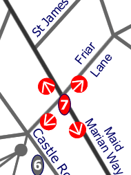
Maid Marian Way cuts through the western side of central Nottingham, both dividing and connecting public space in this part of the city.
"The area of the old town originally within the medieval walls is bounded by Upper and Lower Parliament Streets, the Castle, and Park Row. Since the arterial road, Maid Marian Way, was constructed to complete a ring road round the city centre (1958-66), the w side of the area has been cut off from the rest. Two of the best streets, St James's Street and Castle Gate, are bisected by it. Maid Marian Way, devoid of interesting buildings, has rightly been called "one of the ugliest roads in Europe". Pevsner, N. (1979) The Buildings of England, Nottinghamshire, pp. 228-9.
"In the city centre town planners were faced with reconciling modern traffic needs to the medieval stret plan. Maid Marian Way, built in the 1960's, cut diametrically across the fan of the old Norman streets leading from the Market Square to the Castle. It was a controversial development, and plans were abandoned to construct an urban motorway around the town following a vigorous campaign by the Civic Society. This had been founded in the wake of the construction of Maid Marian Way. 51" John Giggs (1997) A centenary History of Nottingham p. 459.
51 M. Barley, The Chiefest Grain (Nottingham, 1993), p.101
Click each arrow below: